


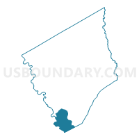
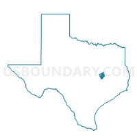
Voting District 0007, Robertson County, Texas
About
Outline

Summary
| Unique Area Identifier | 676560 |
| Name | Voting District 0007 |
| County | Robertson County |
| State | Texas |
| Area (square miles) | 34.80 |
| Land Area (square miles) | 34.45 |
| Water Area (square miles) | 0.35 |
| % of Land Area | 99.00 |
| % of Water Area | 1.00 |
| Latitude of the Internal Point | 30.75670460 |
| Longtitude of the Internal Point | -96.55955070 |
Maps

Graphs
Select a template below for downloading or customizing gragh for Voting District 0007, Robertson County, Texas


Neighbors
Neighoring Voting District (by Name) Neighboring Voting District on the Map
- Voting District 0002, Robertson County, TX
- Voting District 0011, Robertson County, TX
- Voting District 003A, Brazos County, TX
- Voting District 0308, Burleson County, TX
- Voting District 0316, Milam County, TX
Top 10 Neighboring County Subdivision (by Population) Neighboring County Subdivision on the Map
- West Brazos CCD, Brazos County, TX (13,397)
- Hearne CCD, Robertson County, TX (7,327)
- Gause-Milano CCD, Milam County, TX (2,612)
- Cooks Point CCD, Burleson County, TX (1,421)
Top 10 Neighboring Place (by Population) Neighboring Place on the Map
Top 10 Neighboring Unified School District (by Population) Neighboring Unified School District on the Map
- Bryan Independent School District, TX (92,346)
- Caldwell Independent School District, TX (10,193)
- Hearne Independent School District, TX (7,038)
- Gause Independent School District, TX (870)
- Mumford Independent School District, TX (206)
Top 10 Neighboring State Legislative District Lower Chamber (by Population) Neighboring State Legislative District Lower Chamber on the Map
- State House District 20, TX (228,091)
- State House District 17, TX (166,171)
- State House District 57, TX (144,556)
Top 10 Neighboring State Legislative District Upper Chamber (by Population) Neighboring State Legislative District Upper Chamber on the Map
Top 10 Neighboring 111th Congressional District (by Population) Neighboring 111th Congressional District on the Map
- Congressional District 10, TX (981,367)
- Congressional District 31, TX (902,101)
- Congressional District 17, TX (760,042)
Top 10 Neighboring Census Tract (by Population) Neighboring Census Tract on the Map
- Census Tract 2.02, Brazos County, TX (6,688)
- Census Tract 9604, Robertson County, TX (2,935)
- Census Tract 9505, Milam County, TX (2,612)
- Census Tract 9701, Burleson County, TX (1,421)